|
|
Weather Alert |
| Nelson County, VA | |||||||||
|
|
||||||||
|
Canceled 5/14/25 12:37 AM Flood Warning issued May 13 at 10:09PM EDT until May 14 at 1:30AM EDT by NWS Baltimore MD/Washington DC * WHAT... Flooding caused by excessive rainfall continues. * WHERE... Portions of central and western Virginia, including the following counties, in central Virginia, Albemarle and Nelson. In western Virginia, Augusta and City of Waynesboro. * WHEN... Until 130 AM EDT. * IMPACTS... Flooding of rivers, creeks, streams, and other low-lying and flood-prone locations is imminent or occurring. * ADDITIONAL DETAILS... - At 1009 PM EDT, Doppler radar and automated rain gauges indicated heavy rain due to thunderstorms. Flooding is ongoing or expected to begin shortly in the warned area. Between 1.5 and 4 inches of rain have fallen. - Flooding impacts will continue, but no additional rainfall is expected. - Some locations that will experience flooding include... Waynesboro... Stuarts Draft... Crozet... Grottoes... Crimora... Sherando... Shipman... Schuyler... Free Union... Wintergreen... Afton... Montebello... Fishersville... Verona... Weyers Cave... Lyndhurst... Nellysford... Ivy... Greenville... - This includes the following Flood Prone Roads... Route 776 near Route 667, West Leigh Drive/Leigh Way at Little Ivy Creek, Old Ballard Road at Ivy Creek, Ivy Road at Ivy Creek, Three Notchd Road at Route 680, Route 675 at Route 614, Route 614 along Moorman's River, Route 810 near Moorman's River, Route 671 at Moorman's River, Route 631 at Route 706, Route 29/Red Hill Rd at N Fork Hardware River, Route 631 near North Fork Hardware River, Route 20/Route 708 at North Fork Hardware River, Plank Road at Eppes Creek, Plank Road at South Fork Hardware River, Esmont Road along Ballinger Creek, Route 723 near Route 6 at Green Creek, Esmont Road at Totier Creek, Fortune Lane at Totier Creek, Glendower Road at Miller Creek, Route 6 near Totier Creek, Route 737 near Totier Creek, Route 795 near The Hardware River, Route 712 between Route 713 and Route 795, Route 602 at Green Creek, Patton Farm Road at South River, Creekside Mobile Home Park, Route 610 in Sherando at Back Creek, Route 250 at Desper Hollow Road, Route 610 at Route 634, Roseland Road and Virginia 56, Route 617 near Buck Creek, Davis Creek Lane near Davis Creek, Cub Creek Road near Route 56, Route 56 near Campbells Creek Drive, Highway 635 at North Fork of the Rockfish River, Kirby Avenue, 10th St and Jackson Avenue in Waynesboro and A Street at Steele Run. - Please visit www.weather.gov/safety/flood for flood safety and preparedness information 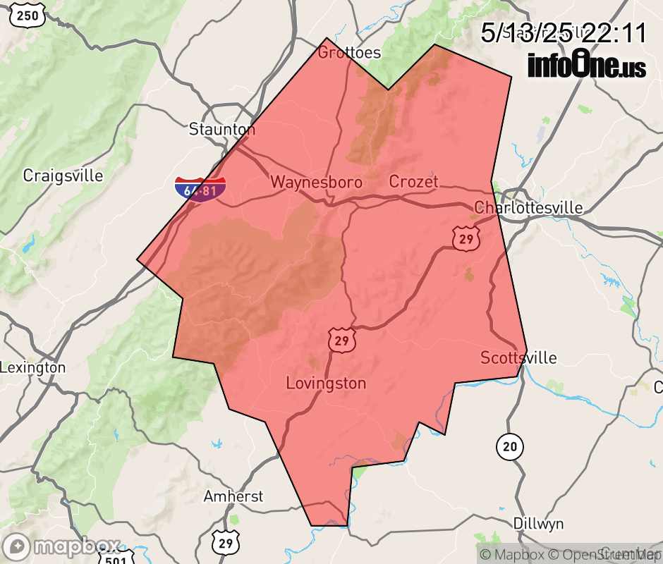 |
|||||||||
 Why aren't you using the InfoOne app? Why aren't you using the InfoOne app?
Stay abreast of information affecting your community! InfoOne tracks real-time information such as:
InfoOne currently supports over 100 communities in NC, VA and WV, and our coverage area is steadily growing. It's free! Install the InfoOne app today and see what you've been missing. |
|||||||||